In Anglo-Saxon England, though the kings were great huntsmen they never set aside areas declared to be outside the law of the land. In the time Edward the Confessor, the Anglo-Saxon King of England (1042 to 1066), parts of the County of Essex were described as a Royal Forest.
After 1066 by royal prerogative, Forest Law was widely applied. (Forest Law is a legal term denoting the Monarch’s right to hunt in the forest) The law was designed to protect the venison red and Fallow deer, Roe, and Wild Boar plus the vegetation that sustained them. Forests were designed as hunting areas reserved for the Monarch or, by invitation, the aristocracy. The concept was introduced by the Normans to England in the 11th century. During the late 12th and early 13th centuries, one third of the land area of southern England was designated as Royal Forest; at one stage in the 12th century, all of Essex was afforested.
Forest Laws were evoked often with severe penalties, with regard to protecting the King’s deer. Offenders caught poaching or disturbing the King’s deer could be executed or maimed, but fines were more profitable. Fences could not be erected to keep deer out. All trees and scrub such as Holly, Blackthorn, Hawthorn and Crab apple, which provided food for the deer, were protected.
Grants were issued by the King to hunt smaller animals.
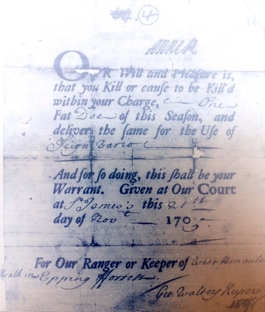
Signed Warrant to Geo(rge) Walters, Keeper of West Henault Walk in Epping Forest authorising him to kill one Fat Doe of this Seafon (Season) for the Ufe (use) of Seigneur Vario. Given at our Court of St. James (Official Residence of the Monarch) dated 21 November 1705. (National Archives SP34/7/4)
The Abbess of Barking was granted venison, timber for building work and cooking. Red deer being reserved for the King. Under license Commoners could put cattle and pigs onto wasteland within the Forest, the cattle to be branded with a Parish Mark by Forest Officials known as Reeves.
The precise boundaries of the Forest of Essex changed under different Monarchs and were a useful source of revenue. Edward I sent his knights out to determine the forest bounds. A detailed list of the bounds and their reasons was accepted and covered much of south-west Essex. Edward II gave the forest rights of Havering to his Queen Isabella, and so they were not subject to Forest Laws and became a Liberty. Following the Dissolution of the Monasteries Henry VIII ordered an inventory of the woodland at Hainault Forest, an area of 3,012 acres. In 1544, George Maxey and William Mildmay surveyed the Crown and former Barking Abbey lands in Hainault Forest and four private woods nearby.
“Furste, in a certen Comen . . . one hill called Greate Hoghill parte Horn-beatne Woode well sett with Oke for Husbandrye, very moche verte of blake Thorne, part lately lopped cont. 63 Acr one roode at 13s 4d (67p) the Acre.”
The forest was managed – partly for hunting which required areas Plains or Lawns to be free from trees because you cannot chase a deer through dense woodland – and partly to provide timber and fuel for the commoners and for the financial benefit of the Crown

Henhault Forest in 1800’s (David Martin)
Note: spelling of Hainault, existence of Fairlop Oak and Hog Hill Pond.
Mention of: The Maypole Inn, The Whale Bone, Henhault Lodge (demolished 1973)
Brick Kiln in Fence Piece, Gravel Pits and Martin’s Wood
In 1791 a survey was published by Joseph Pennington by Order of the Commissioners of the Land Revenue. Appointed by Act of Parliament, the 26 Geo 3. (26th year of reign of King George III). The survey commenced in1785, taking six years to complete.
The published coloured lithograph measures 2 feet x1 foot six (610mm x 488mm) is at a scale of 6 inches to a mile. (1:10,560).
It has a lengthy title: ‘A plan of the lands called King’s Forest or King’s Wood, lying in that part of the forest of Waltham called Hainault Forest and in the Parishes of Barking & Dagenham in the County of Essex.’
By Joseph Pennington 1791, corrected by Fredk A Carrington 1849.
This plan states: No 538. III Ordered by the House of Commons, to be printed 25 July 1848. Henry Hansard Printer
An inset makes reference to a plan of 1791 and names six areas.
Acres Roods Perches
A The King’s Forest or King’s Wood lying open 2,939 2 38
B One piece on the North Side of Hog Hill House 1 2 37
C One piece on the South Side of Hog Hill House 2 2 24
D One piece near Padling Corner 2 1 3
E Chapel Lodge Farm in the possession of
the Warden of the Forest 130 2 2
F Fence Piece Farm held under lease
from the Crown 37 0 32
There follows:
A List of Incroachments
G One piece of ground (Hurds) (i)
H A cottage and gardens (Harris) (ii) 1 1 18
- Near to the Maypole gate
- Difficult to locate this site precisely but the alleged incroachments (sic) in the Chadwell Heath area occurred between 1812 and 1819 (stated on the map).
Lands detached from the King’s Wood (without explanation)
Cattlemans Green 101 0 6
Chadwell Heath 40 2 36
Two pieces of Leyton Marsh the rent for
which is paid to the Keeper of Leyton Marsh 0 2 5
Total 3278 3 2
Land Measure 1 Acre = 4.840 sq yards 1 acre = 0.4047 hectares
1 rood = ¼ acre = 1,210 sq yards 1 perch = 30¼ sq yards
There is a list of Names in the King’s Woods in Waltham Forest mentioned in two Surveys thereof taken the 36th (year of reign) of Henry VIII and the 1st (year of reign) James I.
(In effect this compares names mentioned in the two surveys, but not necessarily mentioned on the map)
In Survey in 36th Henry the 8th (1653) In Survey in 1st James the 1st. (1603).
Great Hog Hill Great Hogg Hill
Woodmans Hill Woodmans Hill
Hingstons Hill Hingstons Hill
Deretop Hill Derelope
Potterspitt Busches Potterspit Hill
Cog Hill Hogg Hill
Chepcote Hill with one piece One other parcel of Wood Ground
At the Frith Gate & a piece at in the same Common
Great Goldhurst Gate
Ravensoke Hill Ravensoak Hill
Bucherhorne Hill Harthorn Hill
Strounde Buschez or Hill Stround Bushes
Martens Buschez Martens Bushes
The Plaine between Strounde Beche Hill
& Martens & forom (sic) Martens Collier Row
to Chigwell waye with gravel One other parcel of Wood Ground
Pitt Busches & pte of Stewards sometimes inclosed (sic) lying within
Wood & betwixt Matrtens Chapel Ditch now open to the
Buschez & Goffez common
Beche Hill
Colinrowe Hill
Penny Hill
Chapell Diche
The Playne within Chappell Diche
Crekel Wood

